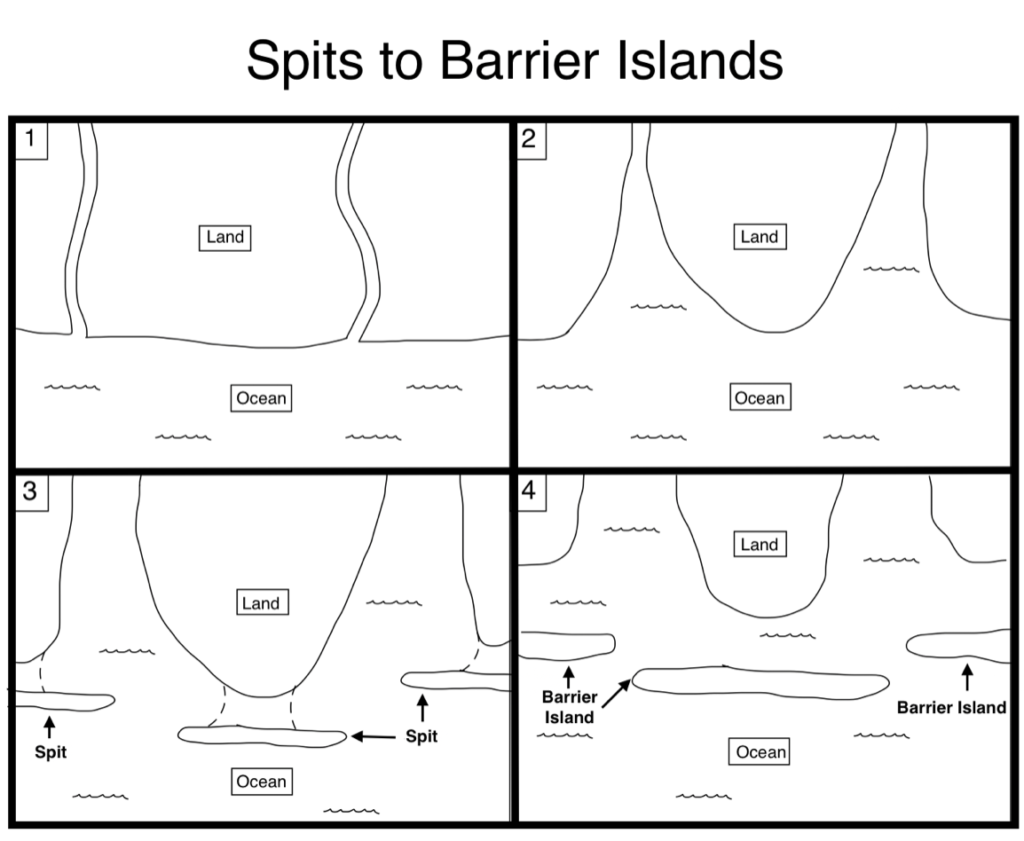
One important thing to note about all shorelines is that they want to be straight (this idea will be revisited with refracting waves), and barrier islands are one way of shorelines keeping themselves straight. After sizable storms, the shoreline is left jagged as water floods the rivers and estuaries which guided water into the ocean. However, as the waves attack the jagged shorelines, the protrusions start to straighten themselves out. This is due to the waves bringing in sand which forms what is known as a spit, where sand slowly accumulates horizontal to the shoreline and travels sideways out from the protruding shoreline. As more and more sand gets layered on these spits from crashing waves and wind blowing from the sand dunes inland, these spits get larger and higher, with their connection to the shoreline growing weaker over time. Eventually once the next storm hits, what land remains connecting the large spit to the shoreline gets flooded, and thus the spit is severed from the mainland and is now officially a barrier island.
Source: Gabe Poulos
Sea Level Fluctuations
Barrier islands form from rising sea levels, with the addition of an adequate amount of sand, a relatively flat slope, and the movement of sand by ocean waves. At present day, the sea level rises approximately 1 foot every hundred years, and that is likely going to increase with global warming. That may seem like a small amount, but it is significant when you factor in how flat the slope of the coastal plane is. Major sea level fluctuations are common in the earth’s geologic history, with the most recent significant sea level rise beginning around 10-12,000 years ago with the start of the current Holocene Era. This rise in sea level was triggered by the warmer temperature after the last ice age which started off melting the ice caps at a rate of 3-4 feet per 100 years, but has since slowed down to the present rate of 1 foot per century. Still, this is a significant amount and causes lots of problems for houses and infrastructure built on the coastline, especially on the occasion of a hurricane or tropical storm (see Coastal Processes and Features section).
Transgression and Regression
A rise in sea level is called a transgression, which causes the shoreline to move inland. A fall in sea level is known as a regression, which causes the shoreline to migrate seaward. These fluctuations in sea level can be caused by several factors, such as tectonic events (like an orogeny, which is the deformation of the crust to create a mountain range), isostatic adjustment (which will be discussed in the piedmont section), or the melting of ice caps, which is the case in North Carolina’s coastal plain.
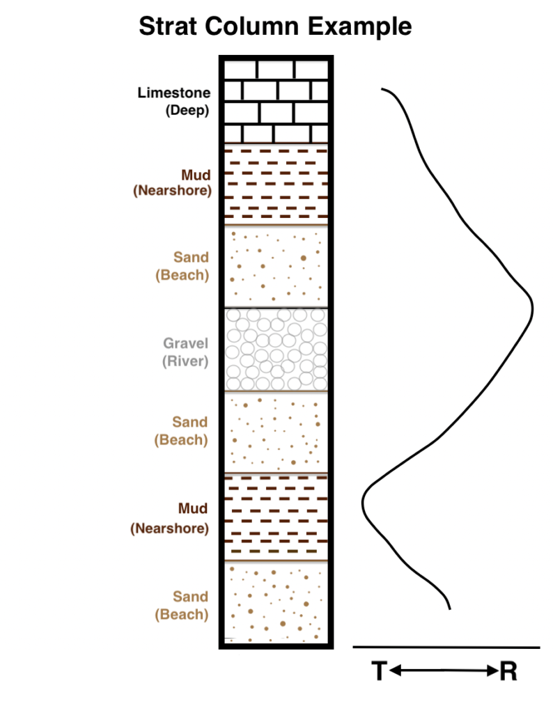
Over the course of geologic history and with numerous transgressions and regressions, these processes leave different sediments layered on top of each other which can be studied and used to lay out a timeline of past geologic and tectonic events. Deposited layers of sediment resulting from a history of transgressions and regressions can be modeled using what is called a Strat Column (short for stratigraphy, which is the study of the horizontal layers of rock sediment). The column represents what it would look like if you were to dig out a large core from a specific location and examine it in one long piece. The figure below is an example of a Strat Column, consisting of different sediment layers and what area of the sea floor they come from, ranging from the rivers inland to the deep ocean. The line moving between the T and R represent each transgression and regression in the column’s history.
Source: Gabe Poulos
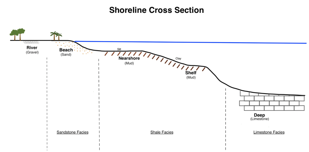
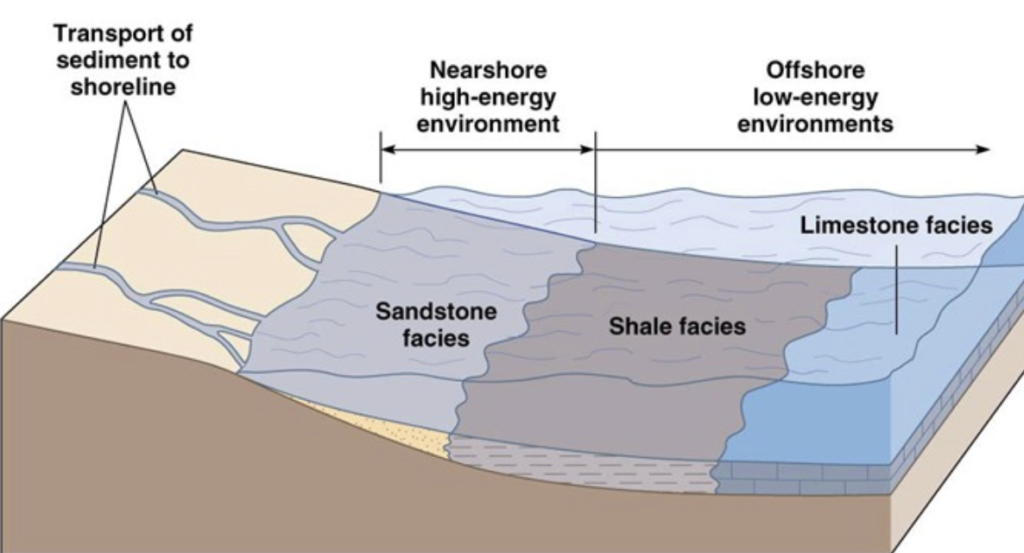
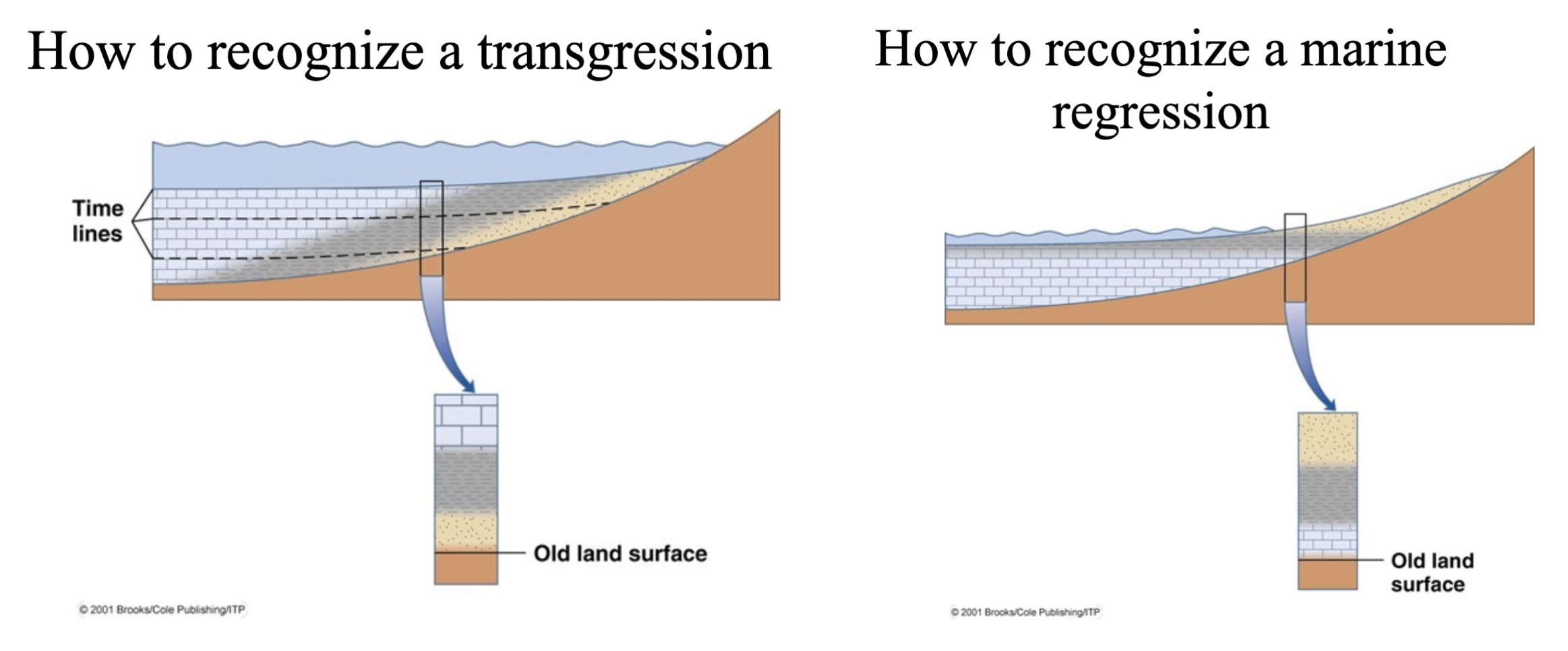
The image below represents the sediments under the ground in each section ranging from inland to the deep ocean. Gravel is furthest inland since it is the result of a past river. Then comes sand which exists on the beach, which turns to mud as you extend out to the nearshore and continental shelf, and finally there is limestone which exists in the deep ocean. The figure also shows that the mud section turns from more silt-rich to clay-rich as it moves further down from the nearshore to the shelf. Since these different materials are always in the same place relative to wherever the shoreline is (sand always comes before the mud which comes before limestone, etc.), geologists can tell when a shoreline has shifted by retracing its stratigraphic history through the layers shown in the Strat Column. When there is a shift from sand to mud in the Strat Column, that means there was a transgression. This is because when the shoreline moves inland, the nearshore mud moves up to where the beach sand used to be, land gets layered on top of it. When there is a shift from mud to sand, that represents a regression, because as the shoreline recedes, the beach area moves further out to where the nearshore was, layering the sand on top of the mud. This same idea is displayed in the figure below labeled “How to recognize a transgression/ How to recognize a marine regression” by identifying that if the limestone is above the sand there’s a transgression, and if it’s below there was a regression.
Source: Gabe Poulos
Source: https://slideplayer.com/slide/4314789/
Source: https://slideplayer.com/slide/4314789/
Barrier Island Rollover
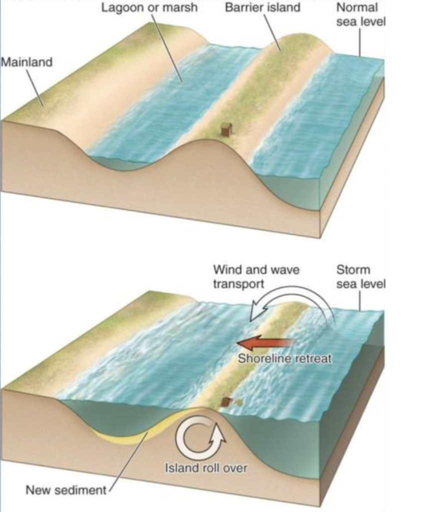
As discussed earlier, barrier islands are small islands that form off the mainland. They often occur in long chains of islands separated by islands that connect the estuaries behind the islands to the open ocean. Their sediment source is the mainland, which they maintain a constant distance from. If the sea level changes, an island naturally migrates landward (if sea level goes up) or seaward (if sea level goes down) to keep a constant distance between the two land areas.
Landward migration of barrier islands is particularly relevant considering contemporary global sea level rise. When sea level rises, the mainland’s shoreline moves landward. This happens during island rollover events, when strong storm waves push sediment across the island to form washover fans of transported sediment. Periodic reenactment of this process effectively moves the island landward over time.
https://en.ppt-online.org/257499
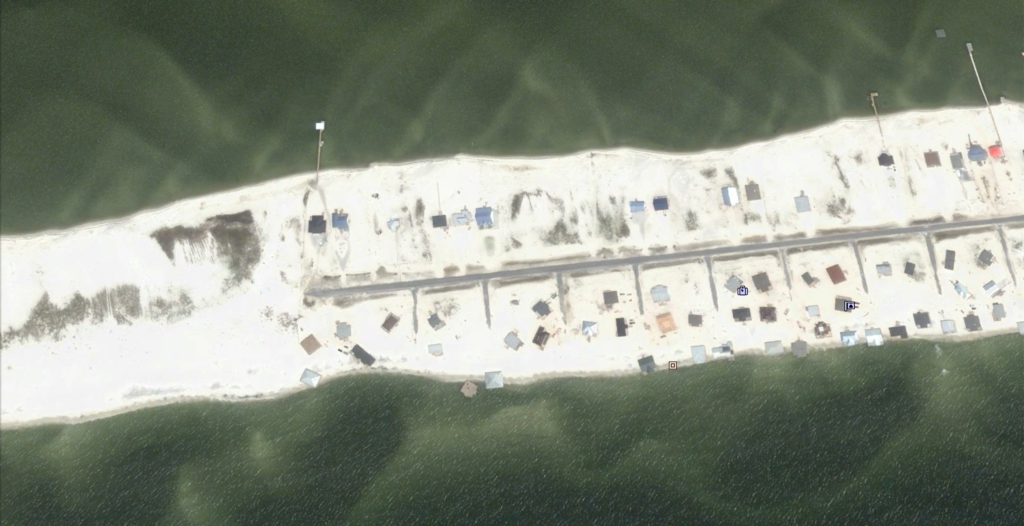
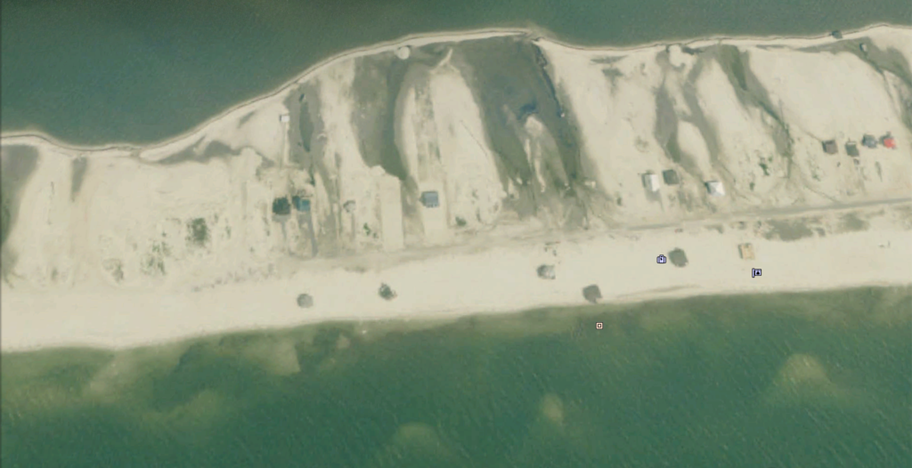
Below is an example of island rollover at Dauphin Island, AL during Hurricane Katrina. The left image shows the barrier island just prior to the hurricane, and the right image shows the island after the hurricane’s waves pushed sand from the front side of the island into washover fans on the back. You can tell how much the island has moved by looking at the relative positions of the road and the houses in the two images.